
Getting ready for a trip in my house usually means hauling out my tourist maps to refresh my memory about where I’m going, what I want to see, and where everything is, relative to each other. According to the modern world, I should be using Google Maps for this task, but oftentimes, I need a much bigger detailed view than my phone allows. So, I revert to my old standby – paper. My current favorite little map is a particular pop-up map series available for most major cities worldwide and small enough to fit in a pocket. That way I don’t look too much like a tourist when I have to pull it out to figure out where I am.
It takes some skill to read a map, figuring out where you are or where you thought you were. My father did not know how to drive so he served as the navigator on family trips. When we got lost or wandered onto unfamiliar roads, it was his job to go into the Esso station office and get us a map, the huge kind that when unfolded, took up the entire front seat. After much wrestling and folding, he would finally find our location and off we would go. Afterwards, it was often my task to refold the map so it fit back in the glove compartment, no mean feat.
Surprisingly enough, the popularity of paper maps had not diminished all that much. Almost every day at the library, I am asked for a map of Princeton, or the campus, something the customers can take with them as they tour. Or at the very least, photocopy a more detailed map we might have or venture out to buy one.
But, what happens to old maps when they get out of date? What if you needed a map of Venice in the 1700s, ancient Rome, Victorian London, the sewer system in Paris, a map from the Revolutionary War that a common soldier might have seen, old New York, old Princeton? Where would you look? How would you find it?
In the early days of my library career, this meant consulting the atlas case, paging through the reference books of maps, scouring books on the topic in question, hoping to find a map, researching articles about maps, basically following a serpentine path through the reference material on hand, until hopefully, striking gold. More often than not, this might have just been a smaller portion of a larger map, tantalizingly close to what was needed. Or maybe you could find that the very map needed did, indeed, exist, but in a library collection in Wisconsin – not very useful for a 7th grade paper due on Monday. Those days were frustrating for librarian and researcher, alike.
Fortunately, modern technology has revolutionized how we search and locate items. In order for there to be items to be digitized, someone, somewhere in time, had to have the wherewithal to collect, or hoard documents for the future. Luckily, many have. Libraries, museums, and local organizations are participating in the creation of digital collections. Mining through archival material, scanning and adding pertinent information, these organizations are dusting off the riches from the past and making more and more of it readily accessible.
Sometimes, it is just the items themselves that are digitized and you are left to explore them on your own. Others take on the form of an online exhibit, much like what you would find in a museum display, where digitized material is explained in an interesting way to tell a story. There is not enough space here to go at length about what is available, but if you have the opportunity, check out the examples that follow.
Still using maps as a focus for digital collections, check out the Library of Congress and its thousands of maps, including some for Princeton, such as A Plan of Princeton, December 31, 1776. Or, take a look at the Sanborn Fire Insurance Maps from all over the country. These were originally created for assessing fire insurance risk and liability, but have great historical value as detailed street maps from all over the country. Princeton University’s collection, available online, is the best place to look for our community.
If you don’t want to take the time to search for yourself, take a look at this Mental Floss article, which highlights 15 great collections. You can get lost forever amongst these treasures.
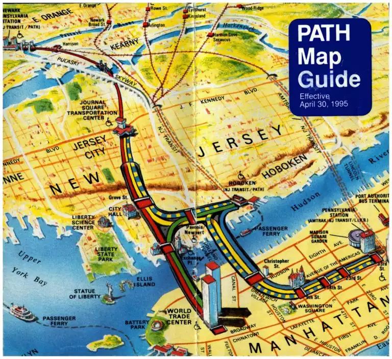
But, even with the increased access to online maps, there’s still something special about a paper map; I especially love the souvenir ones I collect from places I visit. When I hold one in my hand, carefully saved, but maybe haphazardly stored, only to show up unexpectedly one day while sorting through old files, complete with my notes or buildings circled, it invokes strong memories of time and place. Recently, as I was cleaning out my filing cabinet when my department vacated the second floor for the start of the 2Reimagine renovation, I found an old New York Port Authority map for the PATH system, circa April 1995. At first glance, it looked like just any other travel map, until I looked closely and realized that there was one building, actually a pair of buildings, prominently featured. It gave me a moment’s pause as my eye wandered down the page to Lower Manhattan and there they were, the Twin Towers, captured forever on this seemingly innocent little map.
Photo courtesy of the author.
Blog post by Gayle Stratton.